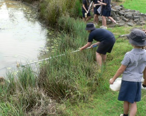
This program addresses Year 7 geography and science topics. Students explore their own and their school's connections to their local catchment through:
 an overview of the local catchment
a catchment crawl
assessing the health of their local waterway/s using biotic and abiotic water quality monitoring techniques
exploring local biodiversity (e.g. birdwatching activity)
learning about Indigenous land and water use
Program details
Venue: Local waterways
Student participation fee - see Booking Information
Duration: 4 hours
Curriculum Activity Risk Assessments (CARAs)
Because the activities associated with Amaroo's Stream Scene program are rated at a low or medium inherent risk level, specific curriculum risk assessment documents for this program are not required. The risk assessment documents below have, however, been prepared by Amaroo staff if you would like to use them. They are partially completed (using the program and site knowledge of Amaroo staff), but relevant details concerning your school/visit should be added once you have downloaded them. Each CARA should be approved by your school principal and filed for your records.
Amaroo Risk Assessment - Biological Activities (PDF, 407KB)
Amaroo Risk Assessment - Bushwalking (PDF, 369KB)
Amaroo Risk Assessment - Maintenance and Operation of a Safe Work Area Outside the Laboratory (PDF, 536KB)
Amaroo Risk Assessment - Pond Scooping & Water Quality Monitoring (PDF, 424KB)
Macroinvertebrate identification key
This program makes use of an app developed conjointly by Griffith University, Natura, Education and the Queensland Outdoor and Environmental Education Centres.
The app is free to download and use.

